
16 Aug Construction Surveying
Drones Help Construction Surveying Processes
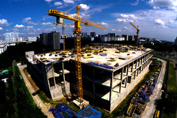
Construction services are aided by new technologies all the time. Drones are changing the way that construction solutions are implemented. One of the stellar solutions that technology brings is that of surveying land. This could cost a great deal of money for many companies, but it’s something that is a lot easier to manage with the help of drones. There are several ways that this helps with construction and processes of varying types. Drones are not the future, they are the present, and are slowly become the standard.
Initial Observations
The initial solution of drones in the air is to help with getting a simple bird’s eye view of different areas. In the past, in order to survey large masses of land, individuals would need to walk throughout various areas, take photographs, notes, and more. This could take a great deal of time and effort, and it’s not something that is done with any sort of speed. Large crews can work together to get this done, but with the assistance of drones, the process becomes a lot easier to work with.
Dispatching an aerial flight solution will allow images to be taken in consideration of large surveying jobs. That can be done with high definition images, 4K video streams, and much more. This can be done from an isolated area, and could very well help continue surveying land and more without having to spend a great deal on crews.
GPS Solutions and Coordinates
Drones today can be used for surveying in a lot of different ways. One of the options that is being utilized is that of global positioning and information that delivers coordinates and more. Modern solutions today are being utilized with what is known as geographical information systems or GIS. This is a solution that allows for simplified topographic and hydrographic mapping. This can help with volumetric calculations, as well as flood mapping, and other maps solutions that can help with surveying land resources for the purpose of insurance, and more.
GIS solutions are important in the surveying world, and can save money for construction crews, as well as surveyors on all levels. It creates substantial resources for maps, coordinates, and much more. Different drones can provide different benefits, and some are made specifically with construction notes etc.
Speeding Up The Process
When you can increase the speed of drones, surveying projects can be done from afar, done fast, and without having to worry about crews and their pace. This also cuts down on costs of hiring pilots, and much more. Speed allows for more efficient design protocol and much more. This is an efficient solution that increases the ratio of mapping solutions, so that companies can deliver on a great deal of information with relative ease.
Accurate information, mapping, and surveying becomes a simplified point of focus with the use of drones. More and more construction companies, and surveying companies are using technologies that allow for easier processing. Whether it’s a matter of money saving, speeding up mapping, or more, you’ll find that drones are impressive in how they work with surveying.